
DEFINITIONS:
Historically the term estuary is the lower reaches of river where she meets with the sea. An estuary can be variously defined. It has been described as the arm of the sea, a firth; “narrow passage, or the mouth of the river or lake, where tides meet the current” (Webster’s New 20th Century Dictionary). Emery and Stevenson (1957) consider an estuary is the wide mouth of the river, or arm of the sea, where tides meet the current of river. According to Ketchum (1951), “An estuary may be defined as a body of water in which river water mixes with measurably dilutes sea water”. But from this definition estuary and lagoons can not be differentiate. A more convincing definition is given by Pritchard (1967): “An estuary is a semi enclosed water body which has a free a free connection with the open sea and within which seawater is measurably diluted with fresh water derived from land drainage”.
Estuaries are typically the tidal mouths of rivers (aestus is Latin for tide), and they are often characterized by sedimentation or silt carried in from terrestrial runoff and, frequently, from offshore. They are made up of brackish water. Estuaries are often given names like bay, sound, fjord, etc. The terms are not mutually exclusive.
CLASSIFICATION OF ESTUARY:
GEOMORPHOLOGIC CLASSIFICATION OF ESTUARY:
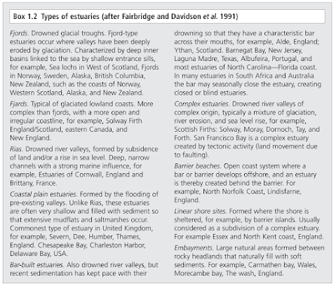
1. Drowned River Valleys: These are classical estuaries, most commonly found along a coastline with a relatively wide coastal plain. Pritchard (1967) designated these waterways as ‘coastal plain estuaries’. The estuary proper in a drowned river valley extends seawards up to the point where seawater is measurably diluted and riverwards up to the point where there is measurable amount of salts derived from sea. As one proceeds from the end to the head of the river, the salinity of river decreases 30 ‰ to 0.1 ‰. Many drowned river valley estuaries were formed between about 15,000 and 6000 years ago following the end of the Wisconsin (or 'Devensian') glaciation when a eustatic rise in sea level of 100 m to 130 m, flooded river valleys that were cut into the landscape when sea level was lower, creating the estuarine systems. Additionally, the general subsidence of coastal regions contributed to the development of drowned river valleys. Well developed drowned river valleys are generally found on coastlines with low, wide coastal plains. Their width-to-depth ratio is typically large, appearing wedge-shaped in the inner part and broadening and deepening seaward. Water depths rarely exceed 30 meters. Examples of this type of estuary include the Chesapeake Bay and Delaware Bay, along the U.S. mid-Atlantic coast, and along the U.S. Gulf coast, Galveston Bay and Tampa Bay.
2. Fjords: Fjord type estuaries are formed in deeply eroded valleys formed by glaciers. These U-shaped estuaries typically have steep sides, rock bottoms, and underwater sills contoured by glacial movement. The shallowest area of the estuary occurs at the mouth, where terminal glacial deposits or rock bars form sills that restrict water flow. In the upper reaches of the estuary, the depth can exceed 300 meters. The width-to-depth ratio is generally small. When estuaries contain very shallow sills, tidal oscillations only affect near surface waters to sill depth, and waters below sill depth may remain stagnant for very long periods of time, resulting in only an occasional exchange of the deep water of the estuary with the ocean. If the sill depth is deep, water circulation is less restricted and a slow, but steady exchange of water from the estuary and the ocean occur. Fjord-type estuaries can be found along the coasts of Alaska, eastern Canada, Greenland, Iceland, New Zealand, and Norway. No fjords occur in India.


3. Bar-built estuaries: These estuaries are semi-isolated from ocean waters by barrier beaches (barrier islands and barrier spits). Formation of barrier beaches partially encloses the estuary with only narrow inlets allowing contact with the ocean waters. Bar-built estuaries typically develop on gently sloping plains located along tectonically stable edges of continents and marginal sea coasts. They are extensive along the Atlantic and Gulf coasts of the U.S. in areas with active coastal deposition of sediments and where tidal ranges are less than 4 meters. The barrier beaches that enclose bar-built estuaries have been developed in several ways: 1) up building of offshore bars from wave action, in which sand from the seafloor is deposited in elongate bars parallel to the shoreline, 2) reworking of sediment discharge from rivers by wave, current, and wind action into beaches, over wash flats, and dunes, 3) engulfment of mainland beach ridges (ridges developed from the erosion of coastal plain sediments approximately 5,000 years ago) due to sea level rise and resulting in the breaching of the ridges and flooding of the coastal lowlands, forming shallow lagoons, 4) elongation of barrier spits from the erosion of headlands, with the spit growth occurring in the direction of the littoral drift due to the action of longshore currents. Barrier beaches form in shallow water and are generally parallel to the shoreline, resulting in long, narrow estuaries. The average water depth is usually less than 5 m, and rarely exceed 10 m. Examples of bar-built estuaries include Barnegat Bay, New Jersey, Laguna Madre, Texas, and Pamlico Sound, North Carolina.
4. Estuaries Produced by Tectonic Process : These estuaries are formed by subsidence or land cut off from the ocean by land movement associated with faulting, volcanoes, and landslides. Inundation from eustatic sea level rise during the Holocene Epoch has also contributed to the formation of these estuaries. There are only a small number of tectonically produced estuaries; one example is the San Francisco Bay, which was formed by the crustal movements of the San Andreas Fault system causing the inundation of the lower reaches of the Sacramento and San Joaquin rivers.
5. Canyon Mouth : Emergent portions of the southern California coastline are characterized by a series of incised, parallel canyons, arroyos or barrancas, and valleys that drain watersheds in mountain, foothill, coastal plain, and coastal mesa landscapes. These various "canyons" empty into the ocean through small estuaries those are quite variable in size, frequency of tidal flushing, salinity regimes, and biota.
6. Estuaries with large areas of sub tidal habitat (bays) and low elevation salt marsh on the bay margins are another major type of estuary.

CIRCULAR CLASSIFICATION OF ESTUARY:
1. Salt wedge: River output greatly exceeds marine input; there is little mixing, and thus a sharp contrast between fresh surface water and saline bottom water. In this type of estuary, river output greatly exceeds marine input and tidal effects have a minor importance. Fresh water floats on top of the seawater in a layer that gradually thins as it moves seaward. The denser seawater moves landward along the bottom of the estuary, forming a wedge-shaped layer that is thinner as it approaches land. As a velocity difference develops between the two layers, shear forces generate internal waves at the interface, mixing the seawater upward with the freshwater. An example of a salt wedge estuary is the Mississippi River.
2. Partially mixed estuaries: As tidal forcing increases, river output becomes less than the marine input. Here, current induced turbulence causes mixing of the whole water column such that salinity varies more longitudinally rather than vertically, leading to a moderately stratified condition. Examples include the Chesapeake Bay and Narragansett Bay.
3. Vertically homogenous estuaries: Tidal mixing forces exceed river output, resulting in a well mixed water column and the disappearance of the vertical salinity gradient. The freshwater-seawater boundary is eliminated due to the intense turbulent mixing and eddy effects. The lower reaches of the Delaware Bay and the Raritan River in New Jersey are examples of vertically homogenous estuaries.
4. Highly stratified: River output and marine input are more even, with river flow still dominant; turbulence induces more mixing of salt water upward than the reverse.
5. Slightly stratified: River output is less than the marine input. Here, turbulence causes mixing of the whole water column, such that salinity varies more longitudinally rather than vertically.
6. Vertically mixed: River output is much less than marine input, such that the freshwater contribution is negligible; longitudinal salinity variation only.
7. Inverse estuary: Located in regions with high evaporation, there is no freshwater input and in fact salinity increases inland; overall flow is inward at the surface, down wells at the inland terminus, and flows outward subsurface. Inverse estuaries occur in dry climates where evaporation greatly exceeds the inflow of fresh water. A salinity maximum zone is formed, and both riverine and oceanic water flow close to the surface towards this zone. This water is pushed downward and spreads along the bottom in both the seaward and landward direction. An example of an inverse estuary is Spencer Gulf, South Australia.
8. Intermittent estuary: Estuary type varies dramatically depending on freshwater input, and is capable of changing from a wholly marine embayment to any of the other estuary types.
NEGATIVE AND POSITIVE ESTUARIES
Negative estuaries - In arid areas “negative estuaries” may form. If evaporation exceeds freshwater input, the back of the estuary becomes a source of dense water saltier than seawater. Now seawater enters at the surface and saltier water from the back of the estuary flows out below. Or In negative (or inverse) estuaries the opposite situation exists, with evaporation from the surface exceeding the freshwater runoff entering the estuary. This type of estuary is mostly found in the tropics, The Mediterranean Sea is a giant negative estuary.
Positive estuaries - An estuary in which there is a measurable dilution of seawater by land drainage or in positive estuaries the evaporation from the surface of the estuary is less than the volume of freshwater entering the estuary from rivers and land drainage. In such a positive estuary the outgoing freshwater floats on top of the saline water, which has entered the estuary from the sea, and water gradually mixes vertically from the bottom to the top. This type of estuary, which is the most typical in the temperate parts of the world, is thus characterized by incoming saltwater on the bottom, with gradual vertical mixing leading to an outgoing stream of fresher surface water.
Neutral Estuaries - Occasionally the freshwater input to the estuary exactly equals the evaporation and in such situations a static salinity regime occurs. Such an estuary is termed a neutral estuary, but they are rare, as evaporation and freshwater inflow are almost never equal.
THE BIOTIC CATEGORY OF AN ESTUARY CAN BE CLASSIFIED AS:
- Oligohaline Organisms – These groups include the fresh water forms of organisms, which can not tolerate the fluctuation of salinity more than 0.1‰. But rarely some species can tolerate the salinity rages up to 5‰ only.
- True Estuarine Organisms – True estuarine organisms, which can tolerate the salinity of wide range, and they can found in entire estuarine regions with different salinities
- Euryhaline Marine Organisms – This group of organisms is found in from sea to upper reaches of the river. These organisms can tolerate low sanity (below 15‰). A few however can tolerate salinities of even 5‰.
- Stenohaline Organisms – These group of organisms can not tolerate low salinity and then only can be found at the river mouth, where the salinity does not reaches at lower than 25‰.
- Migrants – Certain group of organisms are generally living in fresh water or marine water, but due to the specific reasons they migrate to the estuarine regions.
Estuarine Resources of India:
The major estuarine systems of India pertain to the Hooghly-Matlah (the Ganges) estuary in Bengal, the Mahanadi estuary in Orissa, the Godavari and the Krishna in Andhra Pradesh, the Cauvery in Tamil Nadu and the Narmada and the Tapti in Gujarat. The important brackish water Lakes the Chilka Lake in Orissa, the Pulicat Lake in Tamil Nadu and Kerala Backwaters are also our important resources fall under estuarine systems.
THE HOOGHLY MATLAH ESTUARY:
The Hooghly Matlah Estuary located in West Bengal occupies a marshy deltaic area called the Sundarbans. The estuary extends from its mouth to Nawadwip in North and is bound on East by the portions of the Ichamati, Harinbhanga and Gosaba River, and on the West by river Rupnarain, and certain other streams. The Bhagirathi has its five tributaries – Jalangi, Churni, Damodar, Rupnarain and Haldia. In the lower regions of the estuary there are a number of marshy islands. The total approximate area of Sundarban Estuarine waters are about 2,340 sq. km. and can be divided by following zones –
ZONE I – Extends Nawadip to Konnagar and is termed as the upper reaches of estuary with mostly freshwater zone
ZONE II – Extends Konnagar to Diamond Harbor and called the middle reaches of the estuary on the gradient zone
ZONE III – Extends from Diamond Harbor to the mouth of the estuary including entire lower Sundarbans
ZONE IV – Including the Rupnarain River
ZONE V – Including the Matlah around the Port Canning
The main Hooghly Matlah Estuary, according to Pantulu and Bhimchar (1964) is a positive estuary of myxohaline type with approximate triangular shaped mouth and probably due to strong scouring action as well as tidal currents a greater overall circulation is maintained. The tidal influence is left up to a distance of 290km from the sea face. Among the various hydro s biological characters, salinity and temperature are the most important characters determining the fishery of the estuary.
The maximum and minimum temperature are recorded in pre and post monsoon months respectively, however zone wise differentiation of temperature is also recorded. In hydro-biology, the average pH of the water varies 7.6 – 8.5 with total alkalinity of 68 to 195 ppm, silicates 3 – 27 ppm, and dissolve oxygen 5.0 to 10.8 ppm. The salinity of lower zones ranges 1.56 to 30.39 ppm, but almost fresh water condition prevails in upper zone.


